

“California Water System” by Shannon1. Licensed under CC BY-SA 3.0.
With El Niño on its way this year, there are many Californians who are bracing for a deluge of water during the early months of 2016. There are those in that drought-stricken state who are eager for the weather anomaly to come, hopefully bringing with it the intense El Niño rains last seen during the last El Niño of winter of 1997-98. However, as we’ve pointed out elsewhere, this year’s El Niño has just as much chance of bringing arid weather to America’s west coast as it does excessive rains. Even if the deluge does come, there are plenty of reasons to wonder whether California’s public water system is capable of managing the event.
Major plans to develop California’s waterways for the economic development of the state date back to the late 19th century when then-President Ulysses S. Grant commissioned the U.S. Army Corps of Engineers in 1873 to survey the irrigation needs of California’s Central Valley. This investigation led to recommendations for the systematic development of Sierra Nevada watersheds running from northern California through the San Joaquin Valley down to river basins near Sequoia National Park.
Through the middle of the 20th century, development of what would become the California State Water Plan (SWP) was mainly predicated upon the notion of bringing water from reservoirs as far north as Lake Shasta, as well as melting snowpack from Sierra Nevada mountain ranges which feed many California rivers, to southwestern coastal regions of the state which were undergoing large population booms. Major infrastructure construction on the SWP began in 1957 during the Lake Oroville Relocations following central and northern California flooding in late December 1955 that led to 74 deaths and $200 million in economic losses.
As it exists today, the California SWP is the largest state-built water and power development and conveyance system in America. Through it, 25 million state residents and 750,000 acres of irrigated farmland receive the water they all need to function every day. About 70 percent of the SWP feeds water systems in urban areas, the other 30 percent going to feed agricultural systems around the state. In all, the SWP includes 34 reservoirs, lakes and storage facilities, 20 pumping plants, 5 hydroelectric power plants, 4 pumping-generating plants and about 701 miles of canals and pipelines through which public water flows. Without the SWP, two-thirds of California’s residents would be without water.
Supplementing the SWP, and in some cases overlapping with it, is the federally-operated Central Valley Project (CVP) which manages the watersheds of both the Sacramento and the San Joaquin rivers. This more than 400-mile wide expanse, running from the Cascade Mountains in the north down south through Bakersfield, CA, includes 500 miles of canals, 20 dams and reservoirs, 11 power plants and manages 9 million acre-feet of water, equivalent to 2.93 x 10¹² gallons of water. It also provides water to residences, especially in the San Francisco area, as well as for industry and environmental needs.
It should be noted that some of the watershed system feeding into California’s state water supply come from six states through which the Colorado River passes, or from which it drains water. This October 2012 report from the Nature Conservancy of California shows that aqueducts help connect parts of the Colorado River to southwestern California and San Diego.
The multi-year drought has been leading the both the SWP and the CVP towards a critical situation in which a Drought Contingency Plan (DCP) has been developed by multiple state and federal-level agencies. The most recent DCP report, released in January 2015, showed that three major reservoirs all had water levels which were half of their capacity and far below historical averages: Lake Oroville, Lake Shasta and Lake Folsom. Above average rainfall in northern parts of the state was cited as a reason for overall water quality improvement in the Sacramento-San Joaquin River Delta, known locally as the Delta.
So, greater rainfall from El Niño could only help to replenish water levels in California, it would seem. Torrential downpours that brought more than 47 inches of rain to San Francisco in 1997-98 would seem to provide the SWP and CVP with at least some of the great influx of water they both could use to staving off drought concerns for a few years.
Unfortunately, the design of California’s public water management system, along with the typical weather patterns exhibited by El Niño, should conspire to keep the weather pattern from having much of a positive effect on the state’s water situation. Wetter weather, if it does hit, will most likely affect the southern regions of the state while most the state’s large reservoirs, like the Shasta Reservoir, Lake Oroville and the New Melones Lake, are located in the central and northern parts of California. Looking at the most recent U.S. Seasonal Drought Outlook, published by the National Oceanic and Atmospheric Administration’s Climate Prediction Center, El Niño would only affect the southern regions of two states, Nevada and California, of the six western U.S. states within which drought persists or is intensifying: California and Nevada.
There have even been discussions centered on reversing the typical direction of California’s water system to bring water from downstate into central areas of the state. A $6.7 million state project to bring 35,000 acre-feet of water from the Bakersfield region into Silicon Valley through the SWP, which was supposed to start in September, was shelved because of stronger than expected rains this winter.
Despite the major public water works feeding the public supplies for most California residents, the state is criticized by some as poorly managing its own water resources compared to regions around the globe which are experiencing drought or issues of water availability, like areas of Australia, Chile and Singapore. Rules passed by California’s state legislature in 2014 will require greater reporting of groundwater use but don’t require state sustainability goals to be met until 2042, well after it could have a positive effect for the current drought.
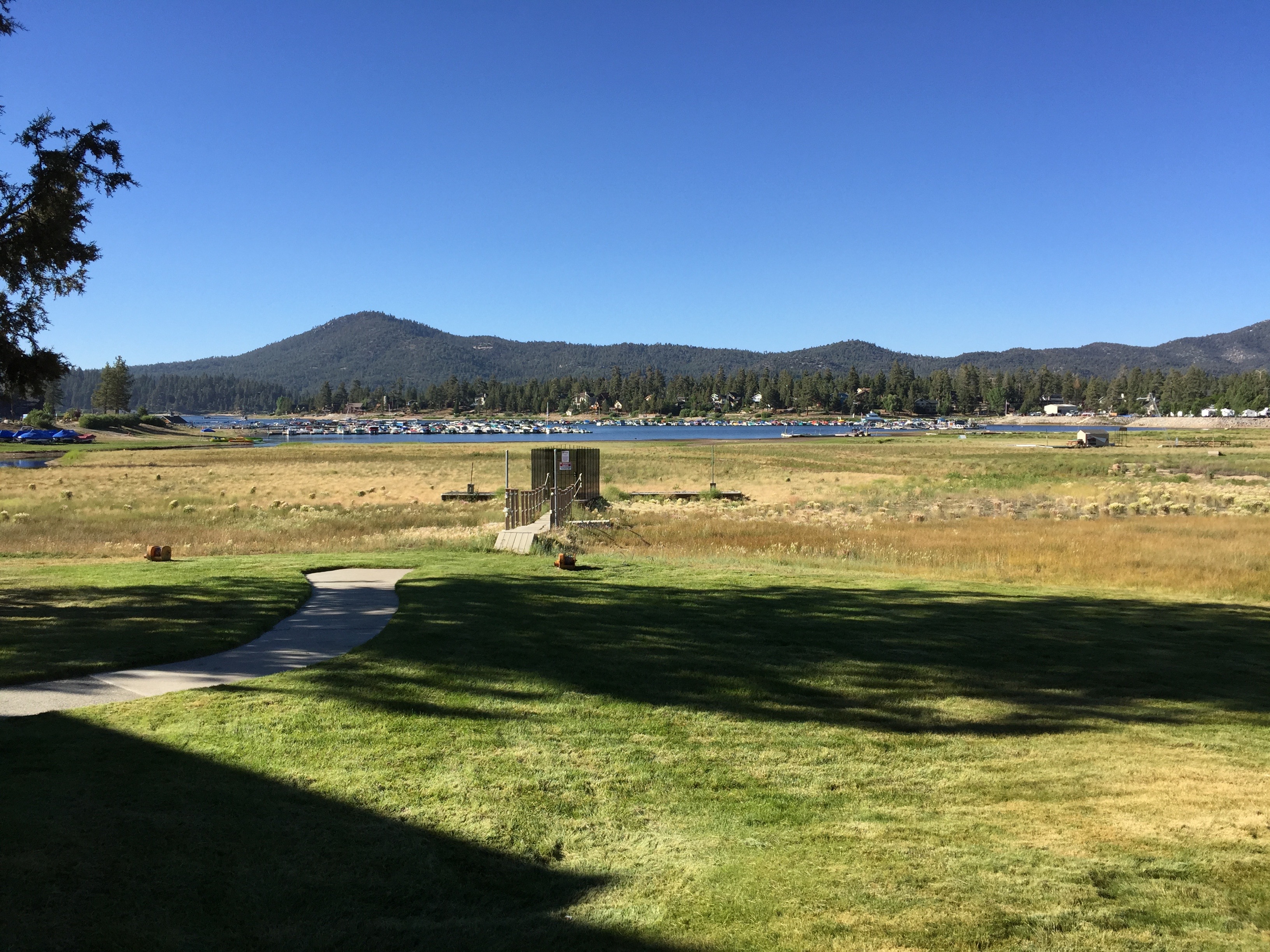
Big Bear Lake, CA. July 2015. To give a sense of the magnitude of the drought, this grass field used to be under water, with boat docks visible.
One region of southern California that could see dramatic improvement is the Big Bear Lake region, which sits over 7,000 feet above sea level. Big Bear, California, located in the San Bernardino Mountains, is approximately 2 hours from Los Angeles and 3 hours from San Diego, sits inland and elevated. There is a man-made lake created by a dam. Originally the dam was built in 1884, with a subsequent larger dam being built in 1912. The water in Big Bear Lake has been precipitously dropping as the drought in California has worsened, but residents are hopeful that record snowfall could significantly raise the level of the lake, which is created only through runoff.
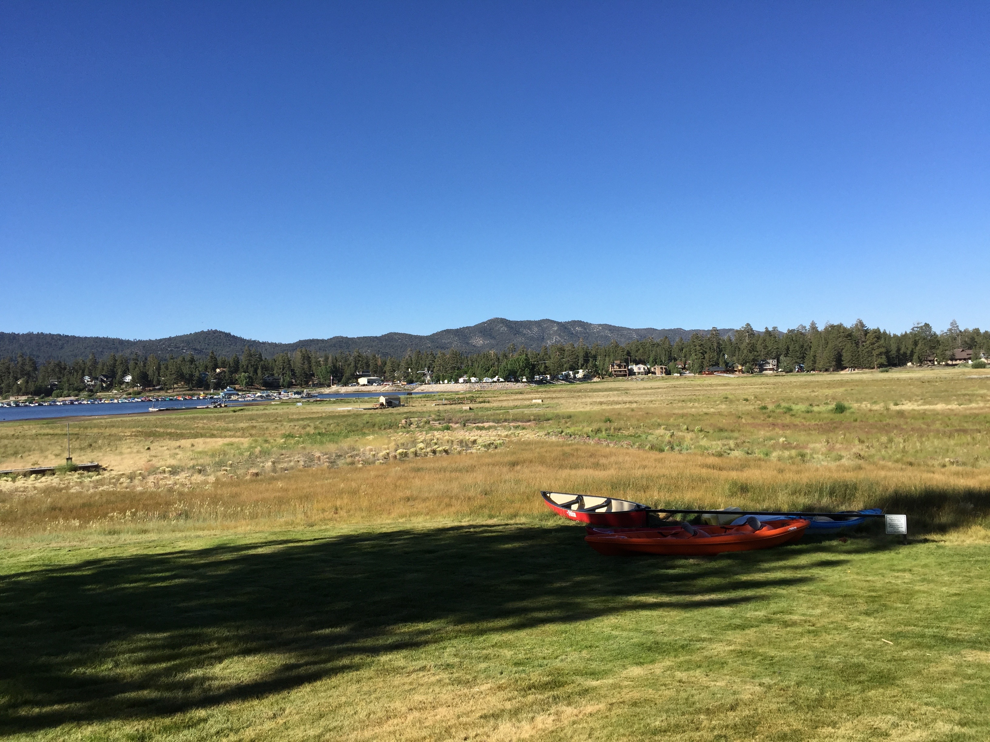
Big Bear Lake, CA. July 2015. This used to be under water.
Unlike Big Bear Lake, which will collect the runoff snowfall or rain, much of the rest of southern California is ill equipped to take advantage of El Niño rains. Those familiar with southern California will know that in beach towns there are signs on or near drains warning people not to dump things into the gutter because whatever goes into the drain will be released into the ocean. That, of course, also means that water that falls in beach communities in southern California will not be collected, or even useful. Due to perpetual poor government planning, even if El Niño does drop large amounts of rain water on southern California much of it will simply wind up in the ocean. Even worse, given the length of the drought and the possible historic rainfall that could occur, massive landslides are a very real concern. This all adds up to southern California likely receiving all the worst a massive rainfall has to offer without any of the associated positive gains.
The El Niño phenomenon, for the most part, is actually well situated to create a pretty dismal water management situation if wet weather does prevail over a dry spell this winter. The last El Niño of 1997-98 was responsible for 17 deaths and about $500 million in damage and this year’s event is already being labelled as the “Godzilla” El Niño by many media outlets because of atmospheric models released by the Climate Prediction Center. In Los Angeles County, officials are readying for the extreme weather pattern by ramping up emergency management plans for flash flooding and mudslides that could occur through early spring of 2016.
To sum up, it’s not an exceptional time to be living in the state of California. In our Disaster Tech series, we noted how California had already seen more wildfires in the first half of 2015 than it did the entire previous year. The state’s historic drought is in its fourth year and if the worst possible scenarios about El Niño are to be realized, California could be dealing with the paradoxical possibility of having to respond to emergency drought and flooding situations.

![[Advertisement]](https://ipwatchdog.com/wp-content/uploads/2024/04/Patent-Litigation-Masters-2024-sidebar-early-bird-ends-Apr-21-last-chance-700x500-1.jpg)

![[Advertisement]](https://ipwatchdog.com/wp-content/uploads/2021/12/WEBINAR-336-x-280-px.png)
![[Advertisement]](https://ipwatchdog.com/wp-content/uploads/2021/12/2021-Patent-Practice-on-Demand-recorded-Feb-2021-336-x-280.jpg)
![[Advertisement]](https://ipwatchdog.com/wp-content/uploads/2021/12/Ad-4-The-Invent-Patent-System™.png)


Join the Discussion
4 comments so far.
John Willkie
September 21, 2015 05:20 amGood overview of predictions which might be interesting for a Southern Californian to review in about 17 months, because one season does not a drought fix. This is one of the many disconnects in the article. Note that the previous big El Nino effect was over two years: the use of 1997-1998 obscures that fact. It was the rainy seasons of 1997 and 1998 that were exceptional, not the end of 1997 and the beginning of 1998 (which most of us Southern Californians would call “the winter of 1998.” Truth be told, it was clear due to the atypically warm (for Southern California) winter last that the El Nino effect seemed to be building, just as happened in 1996.
However, the opening sentence in the last paragraph is belied by current conditions (an exceptionally deep drought of almost 9 years) and the atypical rains (in Southern California of June, July, August and September and which are predicted to build through March, that this is an EXCEPTIONAL time to be living in California. Brown lawns. Skies red with embers.
As to curmudgeon’s ‘point’ there is enough water even currently in Southern California to support agriculture (growers just move to crops that can support the higher costs of water). What the current water supply cannot support is the green lawns that people not living on the edge of deserts take for granted.
Just yesterday, the Metropolitan Water District of Southern California announced it was buying water from Las Vegas. While Lake Mead’s level might be at historical lows, there is excess water in that region for the simple reason that for more than 2 decades, new homes built in the Las Vegas are forbidden to have lawns; gravel, dirt and other seriscape features are the norm there. Take a Google street view of any residential street in Henderson, NV.
Green lawns use up more wather in Southern California than do people or agriculture. I use “the land South of the Tehachipis” as my definition of Southern California.
K.A. Gilligan
September 20, 2015 02:24 pmAgree with the points about needing better water storage systems, not just water run-off into the ocean. This is a serious matter, no doubt about it. The current wildfires in the west are frightening.
Still, don’t write off California just yet. California will adapt, as it always has. We are using far less water than ever before on a per capita basis. We are beginning to modify our water systems to store water, and minimize ground water run off. We are letting lawns go brown. Santa Barbara and San Diego are moving towards desalinization. The list goes on and on.
California innovates and overcomes, and we will do so again. That is what makes the state great, and attracts people from all over the world. If some folks leave and that results in less traffic and lower real estate prices, that would be a bonus for all of us.
Nat Geo wrote about California water conservation.
http://news.nationalgeographic.com/news/2014/05/140508-drought-california-water-shortage-conservation/
Even the New York Times, historically eager to point out California’s flaws wrote a favorable article about how CA is dealing with the drought.
http://www.nytimes.com/2015/08/16/opinion/sunday/how-california-is-winning-the-drought.html
From the NYT: “But across Southern California, the progress is quietly astonishing. The Metropolitan Water District of Southern California now supplies roughly 19 million people in six counties, and it uses slightly less water than it did 25 years ago, when it supplied 15 million people. That savings — more than one billion gallons each day — is enough to supply all of New York City.”
Eleanor
September 20, 2015 12:01 pmGene and Steve – Having grown up in the shadow of Big Bear (down the road, in Cherry Valley), I really enjoyed this article. Your Disaster Tech series is a great concept. Your postings make for engaging and thought-provoking reads. Many thanks!
curmudgeon
September 20, 2015 10:40 amI agree with your basic premise, since Southern CA is a natural desert that never had anywhere nearly enough rainfall to support its present population and agriculture, even by taking lots of water from the entire Colorado River basin. However, re your comment on coastal rain, the last I heard, water does not run uphill. Nor is quickly pumping huge amounts of water long distances uphill so quickly that it does not need to accumulate in a reservoir feasible. So, how likely is it that better “government planning” could build big coastal water reservoirs by tearing down lots of very valuable CA beach front property owned by the wealthy to capture shoreline rainfall?